There have been variations of this Google Maps weirdness floating around on e-mail recently, the most common being New York to London, but essentially the ‘swim the Atlantic’ line occurs for any route between places on either side of the pond thanks to the addition of a route on the map between the ferry terminal in Le Havre, and the end of Long Wharf in Boston. For example, check out this route from the heart of the Kremlin to the White House in Washington DC, and this is apparently the longest route possible at 15,289 miles…
Tag Archives: Google Maps
Another Cool Google Toy

Grabbing a copy of Google Earth today the download page pointed me in the direction of other things that I might find interesting, one of which was Google Mobile Maps. Essentially what it does is take the underlying database used by regular Google Maps, but put a J2ME front end onto the data so that you can access it from a mobile phone.
Of course with the volume of data that Google Maps chucks around, you’d expect the performance to not be exactly stellar, however I was really impressed by the speed with which it generated maps. I put in our post code and it zipped straight to our street. It even has the same choice as the full size Google Maps to switch to a satellite view – the shot above shows the satellite view of the Church.
But it’s not just the maps that have made the transition, it also hooks up to the search facilities to allow you to find local amenities such as restaurants and hotels. Coupled with the fact that it includes the Get Directions facility and it is a fantastic little package. Of course you’ll probably end up paying for it in data charges, but if you find yourself needing a map, all you need now is your mobile phone, nothing else. In fact the only feature it actually lacks, is the ability to work out roughly where you are but I suspect that may turn up at some point too. Even if it’s not something you’re going to use a lot, Google Mobile Maps is definitely a useful tool to have installed onto your phone for an emergency.
Google Maps gets UK Satellite Pics
Thanks to a tip-off from Google Sightseeing I’ve spotted that Google Maps has started providing satellite views of the UK.
Unfortunately the cell covering Arborfield, like much of the current UK coverage is pretty fuzzy, however by some fluke it does have a nice view of the church.

Swiss Mapping Better Than Google Maps?
A few days ago the Scobleizer highlighted a Swiss equivalent to Google Maps.
Having had a play around with it, I’m definitely impressed. It combines both the overhead photography with the maps, by highlighting ground features with icons and symbols where required. More than that, it links to a wealth of information related to the icons. On top of all that it scrolls around and zooms in and out smoothly.
However, it is only really useful if you’re planning on visiting Switzerland…
Google Maps Weirdness
An article on the Register today highlighted an interesting feature of the UK version of Google Maps, which cross references the Yellow Pages with the maps, allowing you to ask for a map of “restaurants in Reading” for example. However it transpires that it also apparently knows about some other places that you wouldn’t expect to turn up in Yellow Pages. The following is a shot of what comes up if you ask for “brothels near maidstone“.
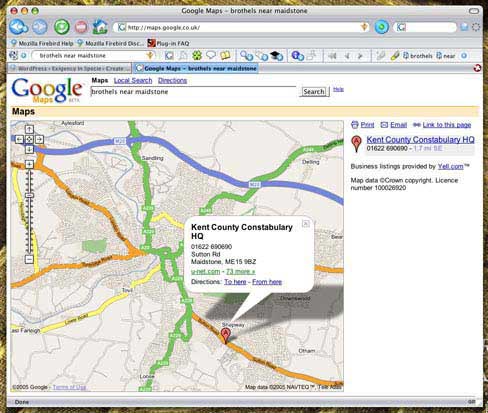
So is it that the Kent Police are branching out? Or maybe it is a suggestion of where you should go if you’re looking for brothels! Incidentally, “brothels in Maidenhead” sends you to the local Catholic church, so maybe it is the latter. Trying “brothels in Micheldever Station” sounds a bit more likely – but could very well be a taxi firm…
As to what the real reason for the strange selection could be, I suspect it is doing some sort of fuzzy text match, however quite what it is matching I don’t know…